1914 Barron Co. Plat Maps

Cedar Lake Township

(Township 36 North, Range 10 West)

Donated by Alice Hain

PLEASE NOTE:  Map image is very large, to enable readability of names, and will take some time to load.  Please be patient while image is loading.  See also the partial index of landowners in this township.


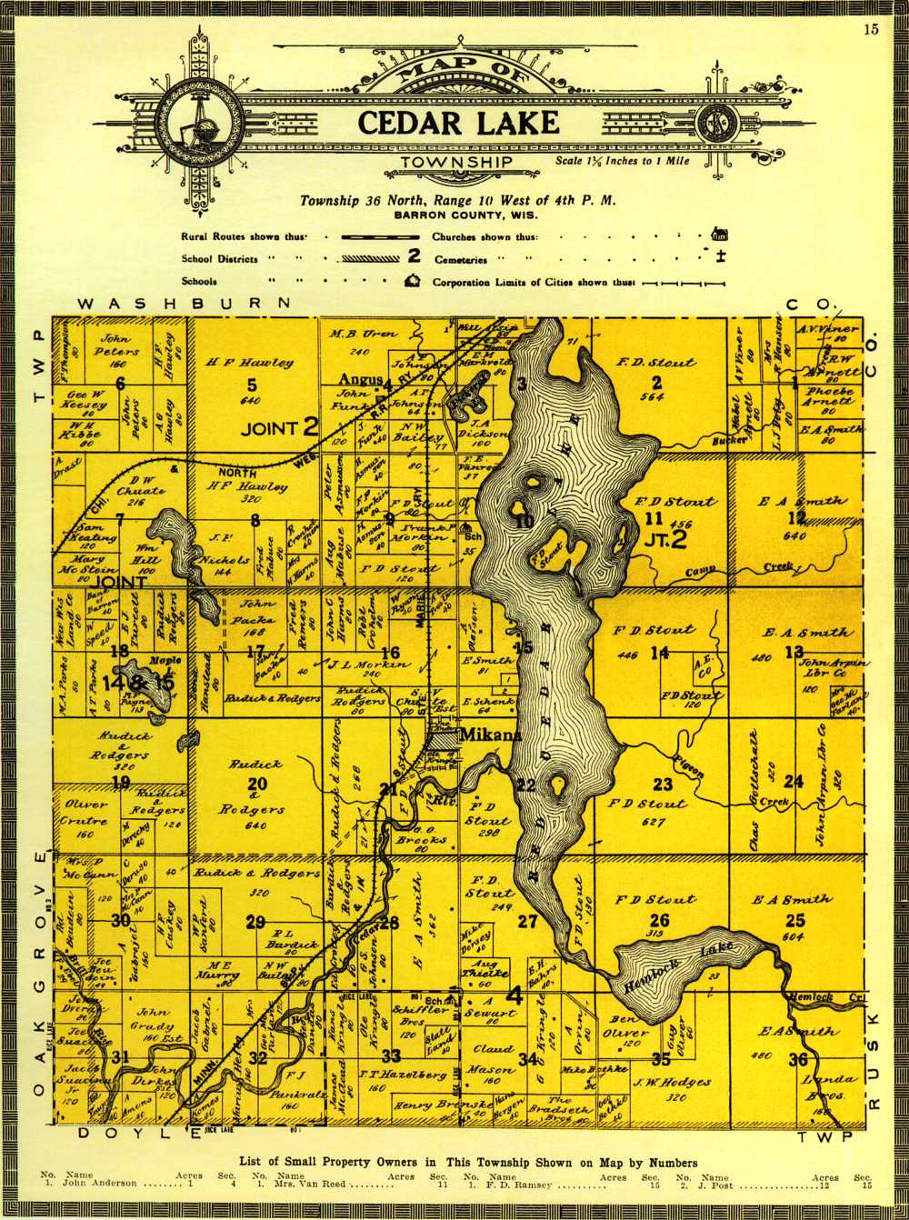
The following names *may* be found on the above township platmap.  Names are spelled as they appear in the 1914 Barron Co. Plat Book Index, and may not be the same as they appear on the map.  This is NOT a complete listing of everyone on the above map.  If you do not see a name listed here, but you know that a particular family lived in this township (owning substantial property), please look at the above map.  Corrections will not be made as this is an accurate copy of the original 1914 plat book, and is represented here as a copy, not a re-writing of history.  Also please note that land owners with multiple section numbers may own land in other townships.  

SURNAME GIVEN_NAME SECTION
ALSIP  William  3
BAHRS  Edward H  27
BOTHKE  Michael  34 & 35
BOUDOIN  Edward  30
BOUDOIN  Joseph  30
BRADSETH BROS    34
BRENSKI  Henry  33 & 34
BROOKS  G O  21
CRONHOLM  Robert  16
CROTTEAW  Edward  28
DIRKES  John  31
DORSEY  Michael  27
DVORAK  John  31
EBEL  Frank  30
FUNK  John  4
GABRIEL  Andrew  30
GABRIEL  Jacob 32
HARNES  John  16
HEFTY  Marcus  32
HILL  William  7
JESSEN  Henry  4
JOHNSON  A T  4
JOHNSON  Gilbert S  28
SURNAME GIVEN_NAME SECTION
KERBER  Louis  32
KOMES  Anton  32
KRINGLE  George G  34
LABREE  Med  33
LANDE  Ben  36
LANDE  Henry  36
LANDE  Lavis  36
MABUSE  August.  9
MARKWALD  Conrad A  3
McCANN  Mrs Peter  30
MORKIN  Frank  9
MORKIN  J L  16 & 17
OLAFSON  Anton  15
OLIVER  Ben  35
OLSON  Carl  33
RASMUSSEN  Peter  9
RYAN  M L  28
SCHIFFLER  Charles  33
SCHIFFLER  Fred  33
SEWART  Alfred  34
SVACINA  Jacob Jr  31
THIELKE  August.  27
WOOD  Eugene  31


Last Update