Welcome to our new 1911 Plat Map page... when I started with the Shawano GenWeb Project in 2001, our neighbour to the east Rita Neustifter, along with the folks at the FHC in Shawano, helped with the 1911 plat maps -- many thanks for their help with the images.  Since then, we redesigned the pages when we acquired clearer images from other sources, resulting in the images being larger and more easily navigated -- many thanks to RMC for his help in the new design, layout and scans.

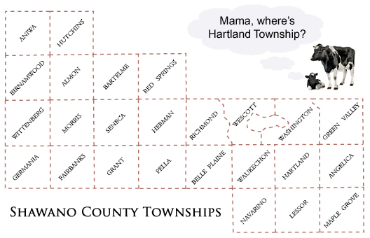
And a word on plat maps -- these are basically FARM LAND MAPS -- they do show the city boundaries but if your ancestors lived inside the towns & cities they generally will not show up on the plat maps or the index...  Each township map is divided into 36 sections... and each section is approximately 640 acres.  Click on the image in the upper right to get a detailed look at how a township is divided into sections as this will help familiarize you with the layout used on all plat maps.

ALMON TOWNSHIP
Twp. 28N - Range 12E
ALMON TOWNSHIP
(now BARTELME TWP.)
Twp. 28N - Range 13E
ANGELICA TOWNSHIP
Twp. 26 - Range 18E
ANIWA TOWNSHIP
Twp. 29N - Range 11E
BELLE PLAINE TWP.
Twp. 26N - Range 15E
BIRNAMWOOD TWP.
Twp. 28N - Range 11E
FAIRBANKS TWP.
Twp. 26N - Range 12E
GERMANIA TWP.
Twp. 26N - Range 11E
GRANT TOWNSHIP
Twp. 26N - Range 13E
GREEN VALLEY TWP.
Twp. 27N - Range 18E
HARTLAND TOWNSHIP
Twp. 26N - Range 17E
HERMAN TOWNSHIP
Twp. 27N - Range 14E
HUTCHINS TOWNSHIP
Twp. 29N - Range 12E
LESSOR TOWNSHIP
Twp. 25N - Range 17E
MAPLE GROVE TWP.
Twp. 25N - Range 18E
MORRIS TOWNSHIP
Twp. 27N - Range 12E
NAVARINO TOWNSHIP
Twp. 25N - Range 18E
PELLA TOWNSHIP
Twp. 26N - Range 14E
RED SPRINGS TWP.
Twp. 28N - Range 14E
RICHMOND TOWNSHIP
Twp. 27N - Range 15E
SENECA TOWNSHIP
Twp. 27N - Range 13E
WASHINGTON TWP.
Twp. 27N - Range 17E
WAUKECHON TWP.
Twp. 26N - Range 16E
WESCOTT TOWNSHIP
Twp. 27N - Range 16E
WITTENBERG TWP.
Twp. 27N - Range 11E
1911 Plat Book
PHOTOS
1911 Plat Book
PATRON DIRECTORY