![]()
![]()
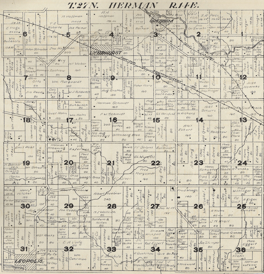
This map will take a while to load and is best viewed "maximized" computer screen width. I decided to keep the maps LARGE so that the names & details are easily read. These Shawano County Plat maps are contributed by Kris Pinkerton, Northeastern Wisconsin area genealogist. Kris has helped me extensively with research at the Diocese of Green Bay, along with Sr. Ella. A big THANKS!!
NOTE: Eventually, we'll try to get these indexed just like the other Shawano County Plat Maps are -- if you have spare time and good eyes and would like to help, just email me and we can assign a plat map to you for indexing. Why index? The search engine for the site sees this map as a picture and does not read any of the names, hence, if you type in "Adamski" in the pico search engine, this page will not show up. If we index it and type the names on the bottom as we've done in the 1911 plats, the search engine will pick these up and display them in the search results.
And, if any of you have plat maps xeroxed, prior to 1930, and would like to share them, let me know! These maps can be a GREAT resource for land deeds when doing research & trying to locate those elusive relatives. The "key" at the bottom lists landowner & acreage if known. ENJOY!
 |
| SECTION 1 | SECTION 2 | SECTION 3 |
| SECTION 4 | SECTION 5 | SECTION 6 |
| SECTION 7 | SECTION 8 | SECTION 9 |
| SECTION 10 | SECTION 11 | SECTION 12 |
| SECTION 13 | SECTION 14 | SECTION 15 |
| SECTION 16 | SECTION 17 | SECTION 18 |
| SECTION 19 | SECTION 20 | SECTION 21 |
| SECTION 22 | SECTION 23 | SECTION 24 |
| SECTION 25 | SECTION 26 | SECTION 27 |
| SECTION 28 | SECTION 29 | SECTION 30 |
| SECTION 31 | SECTION 32 | SECTION 33 |
| SECTION 34 | SECTION 35 | SECTION 36 |
| BACK TO MAP INDEX |  |
BACK TO SHAWANO CO.INDEX |