|
Price County
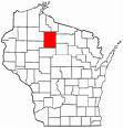
 Price County was created from parts of
Chippewa and Lincoln counties on March 3rd, 1879. The county
was named after W. T. Price, President of the Wisconsin Senate and one of the
first loggers in the county. Price County was created from parts of
Chippewa and Lincoln counties on March 3rd, 1879. The county
was named after W. T. Price, President of the Wisconsin Senate and one of the
first loggers in the county.
Price County is the fifth largest county in Wisconsin measuring thirty-one miles east to west and
forty-two miles north to south. It has a land area of 1,253 square miles of
which 28,500 acres are state-owned; 90,000 acres are county owned; and
147,000 acres make up the Chequamegon National Forest. It has a water area of
25.9 square miles. Prior to the 1860’s, the area that would become Price County was a pristine wilderness rich
in pine and hardwoods.
The area was originally
homelands to the Santee Dakota (Sioux) and later to the Anishinabe (Ojibwe).
Between 1842 and 1854, after pushing the Santee Dakota westward, the Ojibwe ceded millions of acres of the land (including the
area of present day Price County) in Wisconsin,
Michigan and Minnesota to the federal government but
retained exclusive hunting and fishing rights.
In 1864 the voices of
government surveyors broke the silence in the forests as they began to platte the area. Lumber was in great demand at the time
and by the 1870’s lumber companies had moved into the area. As the land
was stripped of its valuable timber, immigrant settlers began to move into
the area purchasing the cut-over lands that had become tax burdens to the
lumber companies. The first settlements were the Town of Brannan
located in the southern third of the County and the Spirit River Settlement
along the Spirit
River.
The community of Elk Lake
formed in 1876 as shanties were erected around the passenger depot built by
the Wisconsin Central Railroad Company. As
the community grew, it was platted by the railroad company and on 23
September 1876 Elk
Lake was renamed
Phillips in honor of Elijah B. Phillips who was one of the town’s
builders. Phillips later became the county seat.
During the winter of 1883-1884,
surveyors for the Minneapolis, Sault Ste. Marie and Atlantic Railroad plotted
a right-of-way through Wisconsin with the
intent to connect Minneapolis, MN with Sault Ste. Marie, MI and thus reduce
transportation costs of Minneapolis
merchant goods. The railroad line was plotted to intersect with the Wisconsin
Central Railroad in Prentice cutting through Price County.
The first train to run between Minneapolis
and Sault Ste Marie was in January 1888. In later railroad mergers, the
railroad became better known as the Soo Line.
As more and more settlers moved
into the area, the need for schools and roads increased along with an
increase in taxes. Disputes over tax assessments led to changes in the
boundaries of the settlements resulting in the formation of new townships.
Swedish, Norwegian and Finnish immigrants
from Iowa and Minnesota were lured to the area by ads
published by the railroad agents and lumber companies advertising rich farm
land at reasonable prices.
Once the land had been depleted
of timber, farming became a predominant livelihood along with logging and
millwork. Many of the early settlements grew into villages, towns and cities
while others disappeared with the lumberjacks.
In 1933, three Civilian Conservation Corps (CCC) camps were established in the county.
The men employed in these camps played a big role in the recovery of the
land.
Today, Price County’s
major industries are wood & paper products, tourism and manufacturing in
addition to farming, transportation and health care. According to the 2000 U.
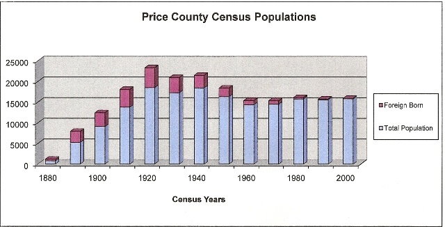
S. Census the County’s population was 15,822. There were a reported
7,949 males and 7,873 females. By 2005, the population was estimated at
15,220. Between 2000 and 2005 there were an estimated 630 births and 983
deaths. For more information on the county’s demographics, visit City-Data.com.
Price County
Census Counts: 1880 -
2000
Data from New York Times Immigration Explorer

Price County
has a rich history! For more information on the various historical sites,
people and places visit the Price
County Historical Society located in Fifield.
Additional links to Price County:
Price County Government: http://www.co.price.wi.us/
Price County Tourism Board: http://www.pricecountywi.net/
Price County at Wisconsin
On-line: http://www.wisconline.com/counties/price/
Back to Top
If you have any
information you would like to contribute, please contact the County Coordinator.
|


