 |
VILAS CountyWISCONSINA WIGenWeb Project |
|
|
|
VILAS CountyWISCONSINA WIGenWeb Project |
|
HOME
Town Offices Chamber of Commerces PROJECTS: History and Biography Indexes Photo Album Surname List Look-Up Volunteers SEE WHAT'S NEW On This Site RESOURCES Books Census Cemetery List Churches Funeral Homes Genealogical Societies Historical Soc. Museums Libraries Newspapers Resource Links Vital Records 
|
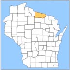
MAPS OF VILAS COUNTYOn this SiteTwo Outline Maps Showing the Boundaries of Towns of Vilas County1898 Map of Oneida, Vilas and Range 4 of Iron counties 1908 Platbook of Wisconsin Lake Region Map of Forest County 1920"s Platbook Maps 1921 Wisconsin Map, 23 pages Giving all Main and Secondary Highways, Railroads On Other SitesCurrent WI State Road Maps are available from Wisconsin Department of Transportation Online They also have large wall maps for sale and county maps that can be downloaded in pdf format. Link to the WIGEnWeb- List of Online Map Resources |
 |
© Copyright: All files on this website are protected by the US Copyright Law, Digital Millennium Copyright Act of 1998, they are not to be copied or altered in any way for commercial use. Individuals may copy the information for their personal use. All persons contributing material for posting on these pages does so in recognition of their free, non-commercial distribution, and further, is responsible to assure that no copyright is violated by their submission. WIGenWeb Vilas County Coordinator Judy Groh |
 |
| . | This page was last updated on -- Tuesday, 22-Feb-2022 12:32:50 CST |