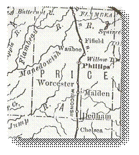
 1881
Price County WI Map
1895 Rand McNally Atlas
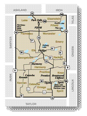
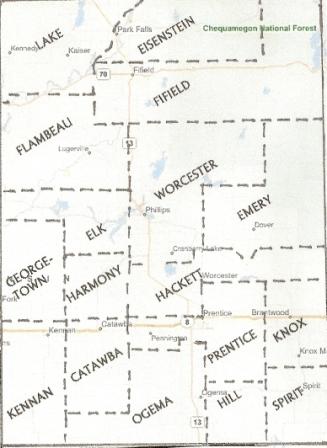
 2007 Price County WI Map |
PLATT BOOK: TOWN OF KNOX T. 35 N. / R. 3 E. Click on photo for larger view: 1910 1957 |
PLATT BOOK: PRICE COUNTY Click on photo for index page: post-1920 |
|
PLATT BOOKS: PRICE COUNTY Click on title for pdf image: Copies of the Price County Platt Books were donated by Kim Potaracke, Archaeological Technician/Passport in Time Coordinator with the Chequamegon-Nicolet Nation Forest Service. Many thanks to her!!! |
||
For additional information on families in
CITIES and VILLAGES, often referred to as "incorporated areas", govern territory where population is more concentrated. In general, minimum population for incorporation as a village is 150 residents for an isolated village and 2,500 for a metropolitan village located in a more densely settled area. For cities, the minimums are 1,000 and 5,000 respectively. As cities and villages are incorporated, they are carved out of the town territory and become independent units no longer subject to the town's control. The remainder of the town may take on a 'Swiss cheese" configuration as its area is reduced.
|
Name |
Towns/Year |
Former Name of Town |
| Brannan | ||
|
Brannon Knox |
Knox
Junction |
|
|
Catawba |
|
|
|
Knox |
|
|
|
Fifield (1895) |
|
|
|
|
Brannon |
Driscoll’s
Spur |
|
|
|
|
|
Elk |
|
|
|
|
Brannan
(1881) |
|
|
Dover |
|
Emery |
| Eisenstein | ||
| Emery | ||
|
Fifield (Nov 1879) |
|
|
|
Flambeau Station |
Eisentein |
Gould Side
Track |
|
Brannan Spirit |
|
|
| Georgetown - The Town of Georgetown was established on December 20, 1887 from part of the Town of Worcester. It was 71 square miles with the Skinner Creek and the north fork of the Jump River running through it. At the time of it's formation it was thickly wooded and settled by only a few folks. | ||
|
Graywood Little information is known about Graywood. It was basically just a post office for one or two years in the late 1800's near the area where County Road YY turns north on the eastern edge of the County. Apparently one of the early settlers to the area had a sawmill in that location and was a postmaster. |
Spirit |
|
|
Hackett - The Town of Hackett was formed from
parts of the Towns of Prentice and Worcester on December 20, 1887. It was 78
square miles with many streams and the Wisconsin Central Rail Road running
through it. Two lakes within the Town form the headwaters for both the north
and south forks of the Jump River. At the time of its formation, the area
was covered in dense forest. The only early settlement in the Town of Hackett was along the Central Wisconsin Rail Road line. A small log station known only as "Station 101" and later called Worcester was short-lived. It had a general store and a post office with the first postmaster being J. A. Carlson. After the railroad extended beyond this stop the station was abandoned and the surrounding areas were settled by Swedish immigrants who established farms. |
||
|
|
Lakes |
|
|
Brannan
Kennan |
|
|
|
Kennedy |
|
|
|
Brannan Knox |
|
|
|
Brannan Knox |
|
|
|
Lake - The Town of Lake was formed from part of the Town of
Fifield on November 22, 1888. It was 108 square miles in size with the
Wisconsin Central Railroad running north/south through it's center. The area contained Butternut Lake and the north fork of the Flambeau River in the midst of an abundance of hardwoods and sparse farm lands. One of the early settlements in the Town of Lake was Park Falls. It was established on the western bank of the Flambeau River and began as a station on the Wisconsin Central Railroad. |
||
|
Le Saulmer |
Location
Unidentified |
|
|
Le Tourneau
Springs |
Location
Unidentified |
|
|
Lugerville |
Flambeau |
|
|
Lymantown |
|
|
|
Mackey’s Spur |
Brannan
Ogema |
|
|
|
Brannan
(1881) |
|
|
Mellrue |
Prentice
(On 1895 Map) |
|
|
Morrison |
Ogema |
Railroad station on the Central Wisconsin Railroad |
|
|
Catawba |
|
|
Brannan
Ogema (1882) |
Brannan |
|
|
Eisenstein Fifield (Nov 1879) |
|
|
|
Brannan Catawba |
Morrisons |
|
|
|
|
|
|
Brannan Prentice |
|
|
|
Spirit |
Brannan Spirit |
|
|
Brannan Spirit |
|
|
|
Sulgrave |
Brannan Kennan |
|
|
Emery |
Also known as the Czech Settlement or the Bohemian
Settlement |
|
|
Wauboo |
|
|
|
|
|
Price County is currently divided into 17 'TOWNS' however, it began
with only two.
When Price County was first formed, it included
two Towns:
Brannan and Worcester.
As more settlers moved
into the county, additional Towns were formed to govern the various
areas of settlements.
They are listed here in order of when
they were formed:
|
|
|
|
|
|
26 Feb
1879 |
One of two original towns in |
|
|
26 Feb
1879 |
One of two original towns in |
|
|
18 Nov
1879 |
Formed form part of Town of |
|
|
15 Jul
1882 |
Formed from part of Town of |
|
|
27 Jan
1886 |
Formed from parts of the Towns of Brannan and
Worcester |
|
|
20 Dec
1887 |
Formed from part of Town of |
|
|
20 Dec
1887 |
Formed from parts of the Towns of Prentice and
Worcester |
|
|
22 Nov
1888 |
Formed from part of Town of |
|
|
08 Jan
1889 |
Formed from parts of Towns of Ogema and |
|
|
09 Jan
1889 |
Formed from parts of Towns of Worcester and
Hackett |
|
|
17 Nov
1892 |
Formed from part of Town of |
|
|
18 Nov
1895 |
Formed from part of Town of |
|
|
15 Nov
1901 |
Formed from part of Town of |
|
|
13 Nov
1902 |
Formed from part of Town of |
|
|
13 Nov
1907 |
Formed from part of Town of |
|
|
01 May
1912 |
Formed from part of Town of |
|
|
27 Jan
1920 |
Formed from parts of Towns of Lake and Elk |
|
|
23 Nov
1921 |
Formed from part of Towns of Brannan |

Copyright © 1996 - The USGenWeb® Project, WIGenWeb, Price County
Design by Templates in Time
This page was last updated 11/10/2024